
PNG
PNG (Papua New Guinea) dataset of 10 sites along a NE-SW line. The data are oriented into geographical coordinate system, with "X" north and "Y" east. The data are stored in zip compression format.
The locations of the sites are given in the png.prf file.
A report of the Zephyr recording crew is given in ASCII file report.txt.
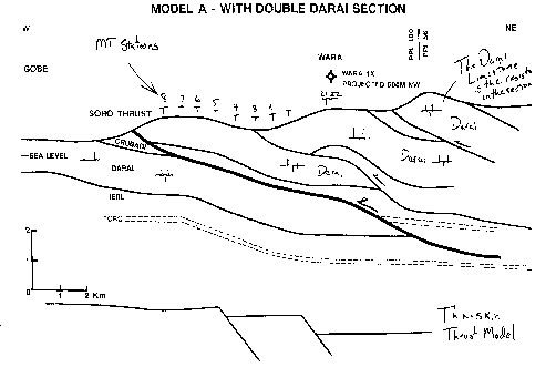
The profile is over a section of Darai Limestone, below which are conducting sediments which may be a source of hydrocarbons. The basic question that Charley Swift wants to address is
"to understand why the thickness of the resistor (the Darai Limestone) from inversions is always less than what we know (or think we know) to be there based upon geological constraints".
Chevron (Australia) would also be interested in any further refinement in the location of the cutoff of the Darai Limestone.
I have been sent copies of two models to explain the data. These I have scanned in and are in zip compressed PostScript format as modA.ps and modB.ps.
The data are stored in both J-format and EDI format
The data were used for examination at the second MT data interpretation workshop, MT-DIW2.
If you use these data in a publication, please inform me so that I can add it to the list below.
Download PNG data in EDI format: sites 1-8
Download PNG data in EDI format: sites 21-22
Download PNG MT data in J-format as a Unix compressed tar file
Download PNG MT data in J-format as a ZIP file
Published papers using or discussing the PNG dataset
- Jones, A.G. and A. Schultz, 1997.
Introduction to the MT-DIW2 special issue.
Journal of Geomagnetism and Geoelectricity, 49, 727-738. - Lilley, F.E.M., 1997.
A critique of the MTDIW2-PNG dat set based on Mohr circles.
Journal of Geomagnetism and Geoelectricity, 49, 807-816. - Pous, J., Ledo, J., and Marcuello, A., 1997.
On the resolution of the Darai limestones by two-dimensional MT forward modelling.
Journal of Geomagnetism and Geoelectricity, 49, 817-826. - Agarwal, A.K., and Weaver, J.T., 1997.
Two-dimensional inversion of Papua New Guinea data using "least-blocked' models
Journal of Geomagnetism and Geoelectricity, 49, 827-842. - Toh H. and Uyeshima, M., 1997.
One-dimensional model study of the PNG dataset using site-independent Groom-Bailey decomposition.
Journal of Geomagnetism and Geoelectricity, 49, 843-856. - Ogawa, Y., 1997.
Two-dimensional inversion of Papua New Guinea magnetotelluric dataset assuming static shift as a Gaussian distribution.
Journal of Geomagnetism and Geoelectricity, 49, 857-868. - Uchida, T., 1997.
Two-dimensional inversion of Papua New Guinea magnetotelluric data with smoothness regularization.
Journal of Geomagnetism and Geoelectricity, 49, 869-878.
Other papers on MT in Papua New Guinea
- Hoversten, G.M., 1996
Papua New Guinea MT: looking where seismic is blind
Geophysical Prospecting, 44, 935-961.